






With today’s 24/7 news cycle, it’s hard to keep up with everything that’s going on. And it’s even more challenging to learn about the past while history is unfolding right in front of our eyes. But if you’re interested in learning about historical items that you probably didn’t hear about in school, you’ve come to the right place, pandas.
We visited the Historical Marvels Facebook group and compiled a list of their most fascinating posts below. From incredible archeological finds to fun facts about the most interesting locations on Earth, we hope you enjoy scrolling through these posts. And be sure to upvote the ones that teach you something new!
#61
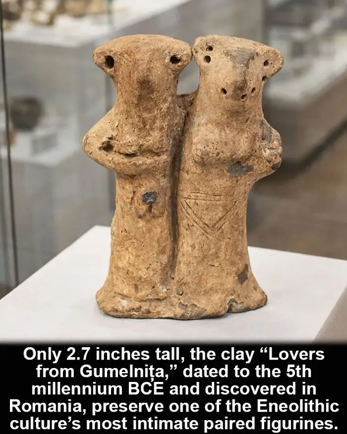
The figures were shaped to sit together. The “Lovers from Gumelnița,” dated to the 5th millennium BCE in present-day Romania, form a small clay pair measuring about 2.7 inches (6.8 cm) in height. The two stylized figures are positioned side by side, creating a compact composition. The surfaces show incised decoration and faint traces of red and white pigment. The clay was hand-modeled and fired, preserving subtle details of posture and symmetry. The arrangement suggests intentional pairing rather than separate figurines later joined. Comparable intimate compositions are rare in the Gumelnița cultural horizon. The object preserves proximity as design. The figurine documents Eneolithic symbolic expression. The precise meaning of the paired figures remains uncertain.
Report
13points
#62
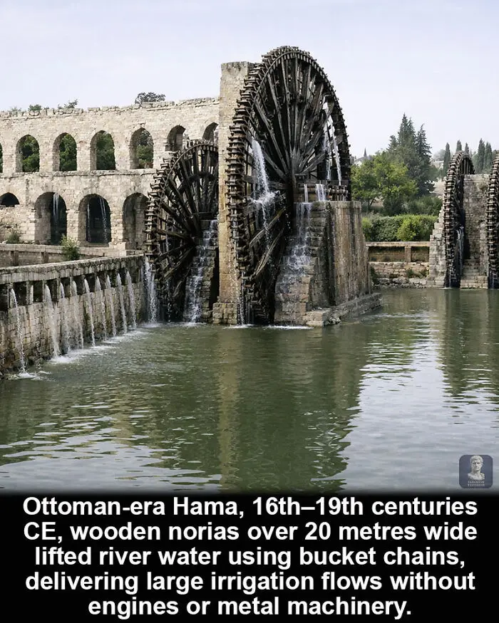
They appear delicate, yet they moved water like industrial machines. In Ottoman-era Hama, Syria, particularly between the 16th and 19th centuries CE, enormous wooden norias rotated in the Orontes River. Some wheels exceeded 20 metres in diameter, with rows of buckets fixed along their rims.
As the current turned the wheels, buckets filled at the bottom and emptied into elevated aqueducts. This continuous motion lifted water to canals feeding gardens and fields. Contemporary estimates suggest flows reaching dozens of cubic metres per hour depending on river conditions.
The structures were built almost entirely from timber, without engines or metal drive systems. Their size and output contrast with their materials. The precise efficiency varied, yet the persistence of these giant wooden hydromechanical machines indicates a long-lived irrigation solution scaled without industrial technology.
As the current turned the wheels, buckets filled at the bottom and emptied into elevated aqueducts. This continuous motion lifted water to canals feeding gardens and fields. Contemporary estimates suggest flows reaching dozens of cubic metres per hour depending on river conditions.
The structures were built almost entirely from timber, without engines or metal drive systems. Their size and output contrast with their materials. The precise efficiency varied, yet the persistence of these giant wooden hydromechanical machines indicates a long-lived irrigation solution scaled without industrial technology.
Report
13points
#63
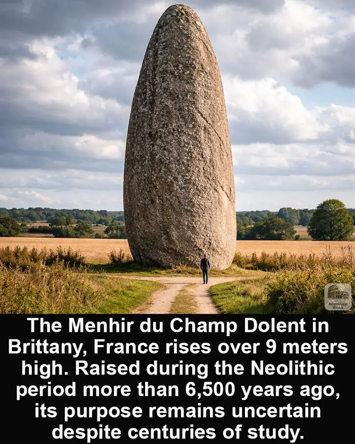
A single stone rising from an open field has watched more than 6 millennia pass. In Brittany, France, the Menhir du Champ Dolent stands as one of the largest surviving standing stones from the Neolithic world. The monument reaches roughly 9 meters (about 30 feet) in height and weighs an estimated 300 tons. It was erected more than 6,500 years ago during a period when prehistoric communities across western Europe began raising large megalithic monuments. Brittany is especially rich in these ancient stones. Thousands of menhirs, dolmens, and stone alignments appear throughout the region, suggesting complex ritual landscapes created long before written history. The exact purpose of the Menhir du Champ Dolent remains uncertain. Archaeologists have proposed several possibilities, including territorial markers, ceremonial gathering points, or monuments connected to seasonal or astronomical observations. Without written records, the original intention behind many megaliths is difficult to confirm. What remains clear is the effort required to raise such a structure. Transporting and erecting a stone of this size would have demanded careful planning and coordinated labor from a Neolithic community with limited technology. Today the monolith still dominates the surrounding fields, a solitary reminder of the societies that shaped the landscape of prehistoric Europe long before cities or kingdoms emerged.
Report
13points
#64
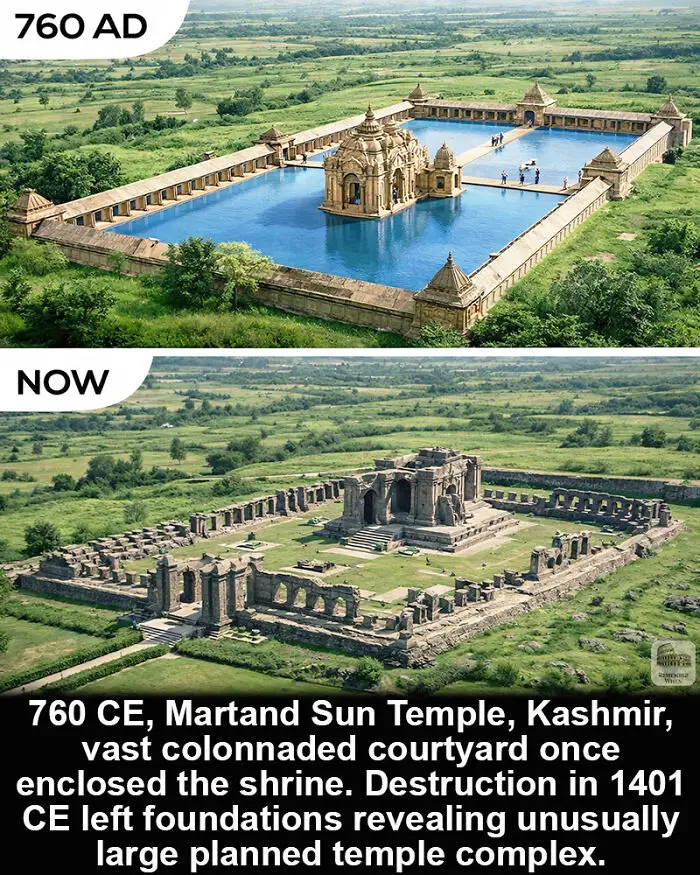
The ruins suggest more than what survives. The Martand Sun Temple in Kashmir, built in 760 CE, once stood within a vast rectangular courtyard surrounded by colonnaded chambers.
At the center rose the main shrine dedicated to the Sun God. The surrounding arcades formed a structured perimeter, creating a monumental open court aligned around the core structure. The scale reflects deliberate planning in Kashmiri temple architecture.
In 1401 CE, the complex was destroyed under Sultan Sikandar Shah Miri. The upper structures disappeared, leaving foundations, walls, and partial colonnades.
Today the layout remains readable. The enclosure outlines the original design, yet much of the vertical architecture is lost. The footprint survives clearly, but the full visual impact of the temple remains open to reconstruction.
At the center rose the main shrine dedicated to the Sun God. The surrounding arcades formed a structured perimeter, creating a monumental open court aligned around the core structure. The scale reflects deliberate planning in Kashmiri temple architecture.
In 1401 CE, the complex was destroyed under Sultan Sikandar Shah Miri. The upper structures disappeared, leaving foundations, walls, and partial colonnades.
Today the layout remains readable. The enclosure outlines the original design, yet much of the vertical architecture is lost. The footprint survives clearly, but the full visual impact of the temple remains open to reconstruction.
Report
12points
#65
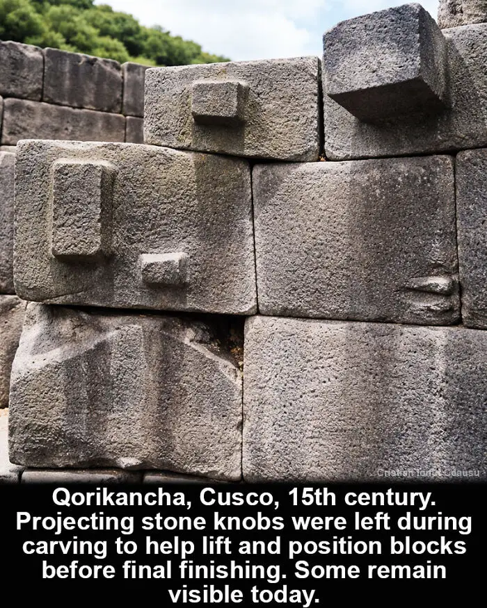
The stones still show how they were moved. At Qorikancha in Cusco, constructed in the 15th century, many blocks include squared protrusions carved directly from the same stone. These features were not decorative. They served as practical grips during construction.
Inca masons shaped the blocks, leaving bosses that allowed ropes or wooden levers to hold and guide each piece. After positioning, some projections were removed, while others were left intact. Their placement varies depending on how each stone was handled.
The result preserves part of the building process in the finished wall. The projections reveal how massive blocks were maneuvered and aligned without mortar.
Inca masons shaped the blocks, leaving bosses that allowed ropes or wooden levers to hold and guide each piece. After positioning, some projections were removed, while others were left intact. Their placement varies depending on how each stone was handled.
The result preserves part of the building process in the finished wall. The projections reveal how massive blocks were maneuvered and aligned without mortar.
Report
12points
#66
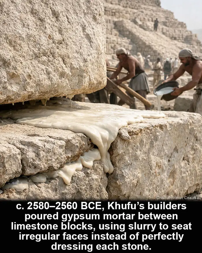
The blocks were not required to match perfectly. Around 2580–2560 BCE, during the construction of Khufu’s pyramid at Giza, Egyptian teams placed gypsum-based mortar between limestone blocks. The material was poured as a slurry, settling into gaps and leveling irregular faces before the stones fully seated.
Microscopic petrographic studies identify deliberate recipes with fine gypsum components mixed for large-scale application. The mortar acted as a bedding compound rather than a strong adhesive. Under weight, it spread and stabilized the courses.
This approach reduced the need for perfectly dressed stone surfaces while maintaining alignment. The exact preparation and mixing process remains debated, yet the repeated presence of controlled mortar layers suggests a practical engineering shortcut built into the pyramid’s construction.
Microscopic petrographic studies identify deliberate recipes with fine gypsum components mixed for large-scale application. The mortar acted as a bedding compound rather than a strong adhesive. Under weight, it spread and stabilized the courses.
This approach reduced the need for perfectly dressed stone surfaces while maintaining alignment. The exact preparation and mixing process remains debated, yet the repeated presence of controlled mortar layers suggests a practical engineering shortcut built into the pyramid’s construction.
Report
12points
#67
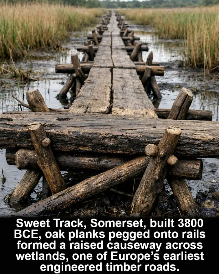
The marsh crossing was built like a planned roadway. The Sweet Track in Somerset, England, constructed in 3800 BCE and dendro-dated from preserved timbers, used paired oak planks laid over supporting rails. Crossed wooden pegs fixed the elements together, creating a stable surface across wetlands.
Thousands of timbers were cut, shaped, and positioned along a defined route. The structure formed a continuous raised causeway rather than isolated stepping platforms. The carpentry required coordinated cutting, transport, and placement of large oak components.
The project suggests organized planning within Neolithic communities. How labor was coordinated remains uncertain, but the pegged plank system represents one of the earliest engineered timber roads in prehistoric Europe.
Thousands of timbers were cut, shaped, and positioned along a defined route. The structure formed a continuous raised causeway rather than isolated stepping platforms. The carpentry required coordinated cutting, transport, and placement of large oak components.
The project suggests organized planning within Neolithic communities. How labor was coordinated remains uncertain, but the pegged plank system represents one of the earliest engineered timber roads in prehistoric Europe.
Report
12points
#68
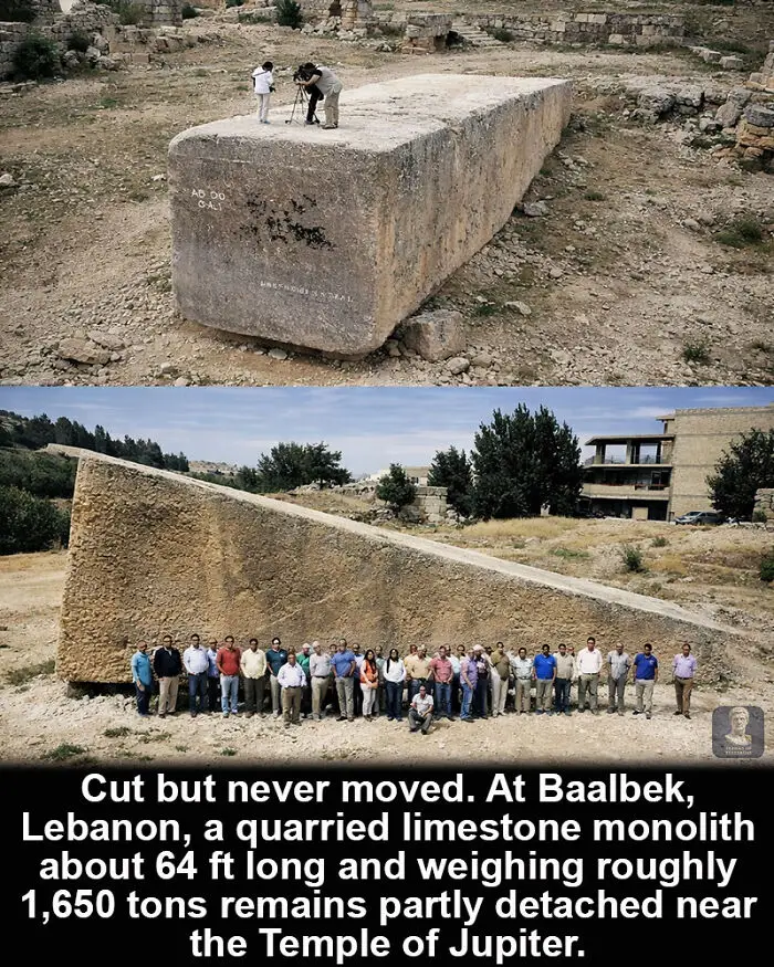
The stone was cut but never transported. At Baalbek in Lebanon, a limestone monolith measuring about 64 ft (19.6 m) in length and weighing roughly 3.3 million lb (1,650 tons) remains in the quarry. The block is partially separated from the bedrock, with cutting channels visible along its sides. Nearby, the Temple of Jupiter platform includes enormous foundation stones. Three of these, known as the Trilithon, weigh around 2 million lb (1,000 tons) each. The construction shows large-scale quarrying and placement of massive blocks during the Roman period. The unfinished monolith indicates even larger plans. The quarry preserves the process. The block demonstrates the scale achievable with ancient stoneworking. The precise reason it was left in place remains uncertain.
Report
11points
#69
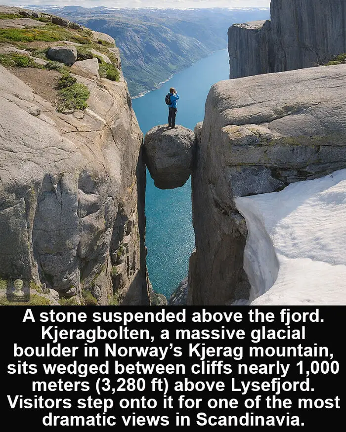
A single stone balanced high above a Norwegian fjord has become one of Scandinavia’s most famous natural landmarks. Kjeragbolten is a large glacial boulder wedged in a mountain crevasse on Kjerag mountain, overlooking Lysefjord in southwestern Norway.
The rock was deposited during the last Ice Age, when glaciers transported and dropped massive stones across the region.
At some point, this particular boulder became trapped between two vertical rock faces, where it has remained for thousands of years.
The site lies about 1,000 meters (approximately 3,280 feet) above the fjord below.
Today hikers follow a challenging trail across the Kjerag plateau to reach the famous rock. Many visitors carefully step onto the boulder to take photographs while standing between the towering cliffs.
Although the drop below is dramatic, the stone itself is tightly wedged and considered stable.
Kjeragbolten has become a symbol of Norway’s rugged landscapes, attracting travelers from around the world who come to experience the unique combination of geology, height, and breathtaking views over the Lysefjord.
The rock was deposited during the last Ice Age, when glaciers transported and dropped massive stones across the region.
At some point, this particular boulder became trapped between two vertical rock faces, where it has remained for thousands of years.
The site lies about 1,000 meters (approximately 3,280 feet) above the fjord below.
Today hikers follow a challenging trail across the Kjerag plateau to reach the famous rock. Many visitors carefully step onto the boulder to take photographs while standing between the towering cliffs.
Although the drop below is dramatic, the stone itself is tightly wedged and considered stable.
Kjeragbolten has become a symbol of Norway’s rugged landscapes, attracting travelers from around the world who come to experience the unique combination of geology, height, and breathtaking views over the Lysefjord.
Report
11points
#70
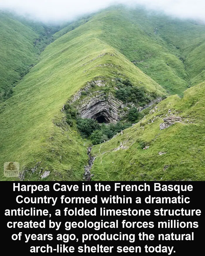
Harpea Cave is one of the most striking natural formations in the French Basque Country. Located near the village of Estérençuby, only a few meters from the border between France and Spain, the cave sits beneath a dramatic folded ridge of limestone. The name “Harpea” comes from the Basque language and means “the place under the rock.”
The formation is part of an anticline, a geological structure created when layers of rock are compressed by tectonic forces and pushed upward into a curved fold. In these structures, the oldest rock layers are found at the center of the fold.
The limestone that forms this ridge developed millions of years ago. Over time, erosion and natural processes carved out the opening beneath the folded layers, creating the cave that can be seen today.
The exposed rock clearly reveals the curved layering created by these ancient geological forces, making Harpea Cave a fascinating natural example of how mountains and landscapes slowly take shape over long periods of time.
Today the site attracts hikers and geology enthusiasts who come to see this unusual cave hidden beneath the folded mountain.
The formation is part of an anticline, a geological structure created when layers of rock are compressed by tectonic forces and pushed upward into a curved fold. In these structures, the oldest rock layers are found at the center of the fold.
The limestone that forms this ridge developed millions of years ago. Over time, erosion and natural processes carved out the opening beneath the folded layers, creating the cave that can be seen today.
The exposed rock clearly reveals the curved layering created by these ancient geological forces, making Harpea Cave a fascinating natural example of how mountains and landscapes slowly take shape over long periods of time.
Today the site attracts hikers and geology enthusiasts who come to see this unusual cave hidden beneath the folded mountain.
Report
11points
#71
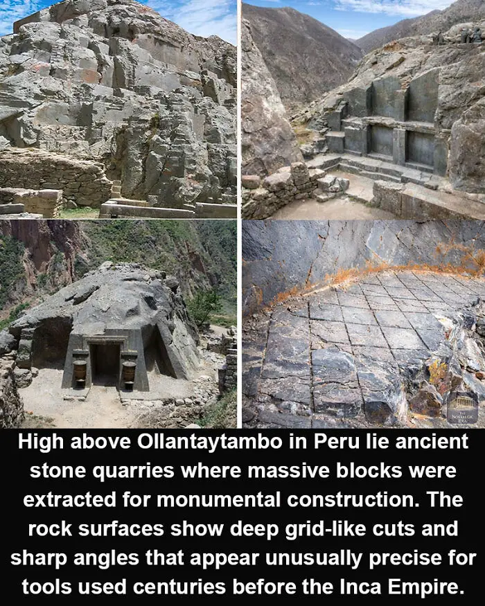
These mountainside quarries in the Sacred Valley contain large rock faces marked by deep channels, straight grooves, and grid-like cuts carved directly into the stone. Many of the surfaces appear unusually precise, forming straight lines and sharp angles across the rock.
The quarry complex was used centuries ago by pre-Inca cultures and later by the Inca civilization, which expanded construction at Ollantaytambo into one of the most impressive fortified and ceremonial sites in the Andes.
The marks seen in the stone likely relate to the process of detaching massive blocks that would then be transported down the mountain. Some of the stones quarried here weigh many tons and were later fitted into temples and terraces in the town below.
Researchers generally believe the cuts were made using stone hammers, chisels, and controlled splitting techniques. Even so, the precision of some quarry marks continues to attract attention.
The quarry clearly shows the stages of ancient stone extraction.
What remains debated is the exact sequence of methods used by Andean builders to shape and separate such enormous blocks from the mountain
The quarry complex was used centuries ago by pre-Inca cultures and later by the Inca civilization, which expanded construction at Ollantaytambo into one of the most impressive fortified and ceremonial sites in the Andes.
The marks seen in the stone likely relate to the process of detaching massive blocks that would then be transported down the mountain. Some of the stones quarried here weigh many tons and were later fitted into temples and terraces in the town below.
Researchers generally believe the cuts were made using stone hammers, chisels, and controlled splitting techniques. Even so, the precision of some quarry marks continues to attract attention.
The quarry clearly shows the stages of ancient stone extraction.
What remains debated is the exact sequence of methods used by Andean builders to shape and separate such enormous blocks from the mountain
Report
11points
#72
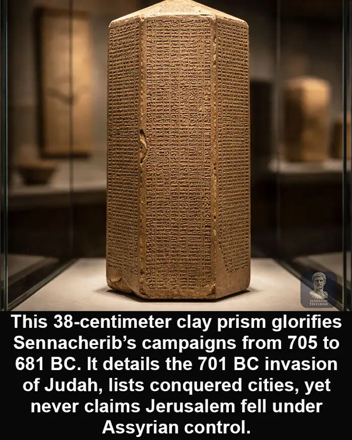
It was written to proclaim dominance. One silence still defines it. The Sennacherib Prism, often called the Taylor Prism, is a 38-centimeter clay artifact inscribed with cuneiform accounts of King Sennacherib’s reign over the Neo-Assyrian Empire from 705 to 681 BC.
Found in 1830 by Colonel Robert Taylor and now housed in the British Museum, it describes the 701 BC invasion of Judah in detail.
Cities are listed as captured. Populations are deported. Jerusalem is surrounded, but not taken.
The text affirms Assyrian power and building achievements. It also leaves historians comparing its claims with the Books of Kings and Chronicles.
The conquest is declared. The absence remains.
Found in 1830 by Colonel Robert Taylor and now housed in the British Museum, it describes the 701 BC invasion of Judah in detail.
Cities are listed as captured. Populations are deported. Jerusalem is surrounded, but not taken.
The text affirms Assyrian power and building achievements. It also leaves historians comparing its claims with the Books of Kings and Chronicles.
The conquest is declared. The absence remains.
Report
11points
#73
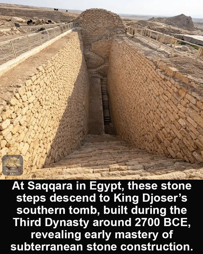
Hidden beneath Saqqara’s sands, the southern tomb of King Djoser dates to Egypt’s Third Dynasty, around 2700 BCE, making it one of the earliest large-scale stone constructions known. The descending stairway carved into the bedrock leads deep underground, showing that Egyptian builders were already working with precision and long-term planning more than 4,700 years ago.
This tomb forms part of the wider Step Pyramid complex at Saqqara, created during Djoser’s reign, a period that marked the transition from mudbrick structures to permanent stone architecture. The uniform steps, steep descent, and carefully aligned walls indicate deliberate engineering rather than experimental construction.
Unlike later royal burials hidden in the Valley of the Kings, this subterranean structure was integrated into a ceremonial landscape visible above ground. Its location, depth, and execution demonstrate that by the Third Dynasty, Egyptian architects had mastered stone cutting, spatial planning, and underground design centuries before the pyramids of Giza were built
This tomb forms part of the wider Step Pyramid complex at Saqqara, created during Djoser’s reign, a period that marked the transition from mudbrick structures to permanent stone architecture. The uniform steps, steep descent, and carefully aligned walls indicate deliberate engineering rather than experimental construction.
Unlike later royal burials hidden in the Valley of the Kings, this subterranean structure was integrated into a ceremonial landscape visible above ground. Its location, depth, and execution demonstrate that by the Third Dynasty, Egyptian architects had mastered stone cutting, spatial planning, and underground design centuries before the pyramids of Giza were built
Report
11points
#74
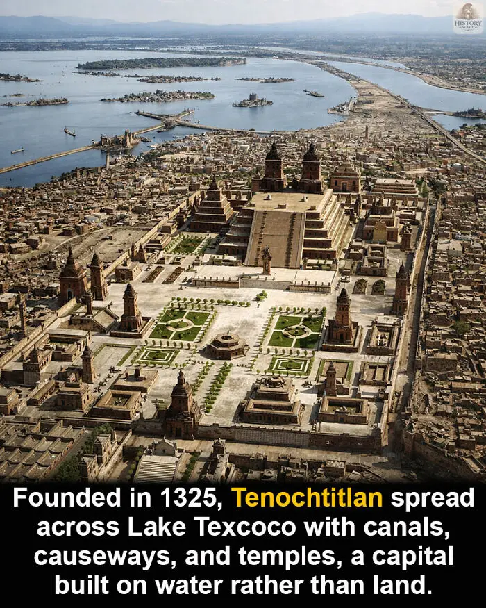
The capital stood on water, not solid ground. Founded in 1325 on Lake Texcoco, Tenochtitlan became the center of the Aztec Empire, built with canals, causeways, and artificial islands. Movement through the city relied on boats, while raised roads connected districts to the mainland. The urban plan adapted architecture to a lake environment.
Ceremonial temples rose above the central precinct, surrounded by gardens and neighborhoods arranged across chinampas. Waterways structured daily life, trade, and transport, turning canals into primary routes instead of streets. The city combined hydraulic engineering with monumental construction.
Spanish descriptions and archaeological remains confirm this layout. The structure is clear, yet population estimates and circulation patterns remain debated. The lake setting defined the city. The full scale of its activity remains partly inferred.
Ceremonial temples rose above the central precinct, surrounded by gardens and neighborhoods arranged across chinampas. Waterways structured daily life, trade, and transport, turning canals into primary routes instead of streets. The city combined hydraulic engineering with monumental construction.
Spanish descriptions and archaeological remains confirm this layout. The structure is clear, yet population estimates and circulation patterns remain debated. The lake setting defined the city. The full scale of its activity remains partly inferred.
Report
9points
#75
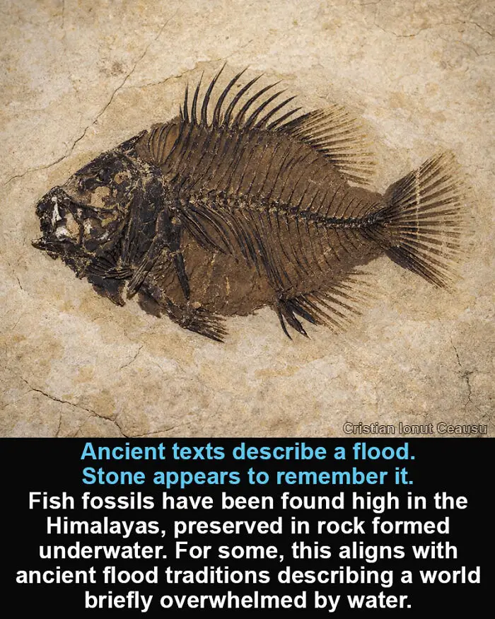
The highest mountains were not always above the sea.
Marine fish fossils have been discovered near the upper reaches of the Himalayan Mountains, preserved in sedimentary layers formed underwater. The species are unmistakably marine, yet today they rest thousands of meters above any ocean.
Modern geology explains this through tectonic uplift, as the Indian plate collided with Eurasia and slowly raised former seabeds into mountains. The process is documented. The timeline is long. What remains unsettled is whether this explanation alone accounts for the global pattern of marine fossils found on high land across continents.
Ancient texts describe a different world order. The Biblical Flood speaks of waters covering all terrain, erasing distinctions between sea and summit. Similar flood accounts appear in Mesopotamian, Asian, and Indigenous traditions.
The fossils do not interpret themselves. They simply remain where water once was. Whether they reflect slow upheaval, a catastrophic flood remembered in scripture, or an overlap of both is still debated.
Marine fish fossils have been discovered near the upper reaches of the Himalayan Mountains, preserved in sedimentary layers formed underwater. The species are unmistakably marine, yet today they rest thousands of meters above any ocean.
Modern geology explains this through tectonic uplift, as the Indian plate collided with Eurasia and slowly raised former seabeds into mountains. The process is documented. The timeline is long. What remains unsettled is whether this explanation alone accounts for the global pattern of marine fossils found on high land across continents.
Ancient texts describe a different world order. The Biblical Flood speaks of waters covering all terrain, erasing distinctions between sea and summit. Similar flood accounts appear in Mesopotamian, Asian, and Indigenous traditions.
The fossils do not interpret themselves. They simply remain where water once was. Whether they reflect slow upheaval, a catastrophic flood remembered in scripture, or an overlap of both is still debated.
Report
9points
#76
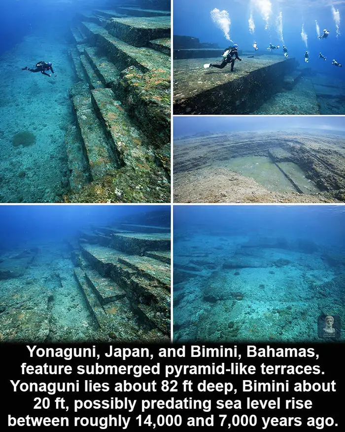
Two submerged sites continue to divide interpretation. Near Yonaguni Island, Japan, about 62 miles (100 km) east of Taiwan, massive stepped rock formations descend to roughly 82 ft (25 m) underwater. Marine geologist Masaaki Kimura has suggested they resemble terraces, platforms, and pyramid-like structures.
Across the Pacific, the Bimini Road in the Bahamas stretches about 1,476 ft (450 m) beneath roughly 20 ft (6 m) of water. The formation consists of large rectangular limestone blocks arranged in a linear pattern extending from North Bimini Island. Radiocarbon dating of fossil shells within the stones has been cited at around 3,500 years old.
Global sea levels rose about 459 ft (140 m) between roughly 14,000 and 7,000 years ago, flooding extensive coastal regions where early populations lived.
Some researchers interpret both sites as natural geological formations. Others point to alignment and stepped geometry. The structures are mapped, but whether they reflect geology or submerged construction remains debated.
Across the Pacific, the Bimini Road in the Bahamas stretches about 1,476 ft (450 m) beneath roughly 20 ft (6 m) of water. The formation consists of large rectangular limestone blocks arranged in a linear pattern extending from North Bimini Island. Radiocarbon dating of fossil shells within the stones has been cited at around 3,500 years old.
Global sea levels rose about 459 ft (140 m) between roughly 14,000 and 7,000 years ago, flooding extensive coastal regions where early populations lived.
Some researchers interpret both sites as natural geological formations. Others point to alignment and stepped geometry. The structures are mapped, but whether they reflect geology or submerged construction remains debated.
Report
8points
#77
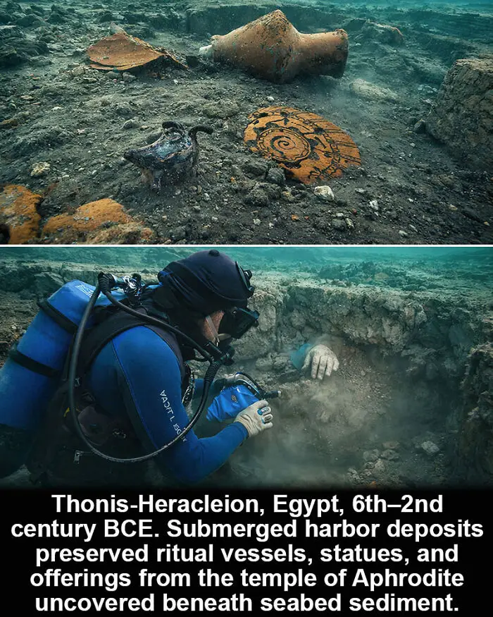
The ruins lie where ships once anchored. Thonis-Heracleion, Egypt, flourished between the 6th and 2nd centuries BCE as a major port at the Nile’s Mediterranean entrance. Earthquakes, subsidence, and soil liquefaction caused large sections of the city to sink, sealing temples and harbor structures beneath sediment.
Marine excavations uncovered ritual vessels, statues, and offerings from a sanctuary associated with Aphrodite. Pottery, cult objects, and architectural blocks remained where they fell. The sediment preserved fragile materials and spatial relationships.
The underwater remains show a functioning port where Egyptian and Greek practices overlapped. The finds document ritual activity inside a harbor district. The city survives as a submerged archaeological landscape.
Marine excavations uncovered ritual vessels, statues, and offerings from a sanctuary associated with Aphrodite. Pottery, cult objects, and architectural blocks remained where they fell. The sediment preserved fragile materials and spatial relationships.
The underwater remains show a functioning port where Egyptian and Greek practices overlapped. The finds document ritual activity inside a harbor district. The city survives as a submerged archaeological landscape.
Report
8points
#78
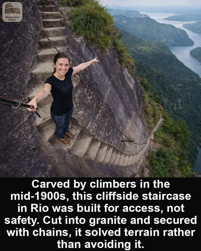
This exposed staircase on the cliffs of Rio de Janeiro was not built as a monument or a tourist attraction. It was carved gradually in the mid-20th century by climbers and hikers accessing steep granite routes in the Tijuca Massif, most commonly associated with trails leading toward Pedra da Gávea.
The steps were cut directly into the rock to solve a practical problem. Sheer slabs offered no safe footing, especially in rain. Rather than reroute the path, climbers carved narrow footholds and installed chains anchored into the cliff to assist ascent and descent. The goal was access, not comfort. No machinery, no large-scale planning, just hand tools, experience, and repetition over time.
What remains today is a hybrid structure. Part trail, part climbing route. It reflects a period when exploration preceded regulation, and terrain was adapted minimally to human movement rather than reshaped. The staircase exists because people needed to pass here, and chose the cliff instead of the long way around.
Report
8points
#79
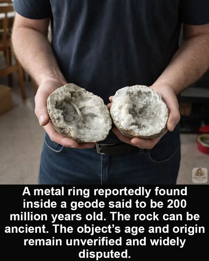
The rock may be ancient. The claim requires proof. Geodes are natural rock formations that develop when mineral-rich fluids fill cavities inside volcanic or sedimentary rocks.
Over long periods, crystals form within, sometimes in formations linked to rocks hundreds of millions of years old.
Stories have circulated about a metal ring allegedly discovered inside a geode said to be over 200 million years old. Such accounts often imply an artifact older than human civilization.
Yet geology and archaeology require careful documentation. The age of a geode refers to the host rock, not automatically to any object associated with it. Without controlled excavation records, laboratory analysis, and peer-reviewed publication, extraordinary conclusions cannot be confirmed.
Claims of ancient or extraterrestrial origins remain speculative.
What endures is a reminder that evidence, not mystery alone, determines history.
Over long periods, crystals form within, sometimes in formations linked to rocks hundreds of millions of years old.
Stories have circulated about a metal ring allegedly discovered inside a geode said to be over 200 million years old. Such accounts often imply an artifact older than human civilization.
Yet geology and archaeology require careful documentation. The age of a geode refers to the host rock, not automatically to any object associated with it. Without controlled excavation records, laboratory analysis, and peer-reviewed publication, extraordinary conclusions cannot be confirmed.
Claims of ancient or extraterrestrial origins remain speculative.
What endures is a reminder that evidence, not mystery alone, determines history.
Report
6points
