




Photographer Benjamin Grant has set off on a mission to change the way we see our planet with his stunning photo project - Daily Overview.
Every single day, Grant shares one satellite photo from Digital Globes to change the way we see our planet. "With a focal length 16 times longer than a standard DSLR camera, the cameras are so powerful that you can take a picture of a beach ball on the Golden Gate Bridge in full resolution…from Los Angeles," Grant told Bored Panda. "I try to present the images with no bias and let people decide what these altered landscapes mean, based on the facts and the visual evidence in the frame. I believe that this perspective is a means to start a conversation about the condition of our planet and how we can better protect it."
"I create the images by stitching together numerous high-resolution satellite photographs. I partnered with a satellite company called DigitalGlobe and accordingly have access to their full archive of imagery. Once I have put together a composite image, I then treat it like a photograph to make it as crisp and easy to understand as possible to accentuate certain patterns, colors, or places." The results are so amazing, Grant has even put together a book of over 200 high-resolution satellite photographs. It's titled "Overview: A New Perspective of Earth", and can be purchased through Amazon.
This post may include affiliate links.
#21 Cairo, Egypt

29°58′34″N 31°7′58″E. The Great Pyramids of Giza are located on the outskirts of Cairo, Egypt. Dating back to 2580 BC, the Great Pyramid, the largest structure at the site, is the oldest of the Seven Wonders of the Ancient world and the only one to remain largely intact. With an estimated 2,300,000 stone blocks weighing from 2 to 30 tons each, the 481 foot pyramid was the tallest structure in the world for more than 3,800 years.
24points
#22 Central Park, New York City, New York, USA

40°46’56”N; 73°57’55”W. Central Park in New York City spans 843 acres. That’s 6% of the island of Manhattan.
23points
#23 Salt Ponds, San Francisco Bay, California, USA
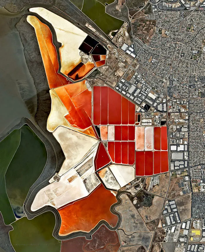
37.5106531, -122.053325. The salt evaporation ponds seen here cover roughly 10 square miles (26 square km) in San Francisco Bay, California, USA. Salt is extracted from the water here through a lengthy process. First, water from the bay is channeled into massive basins where it begins a transformation into brines. Over five years, the brines evaporate, concentrate, and travel several miles before they are collected as pure salt crystals. The massive ponds get their vibrant color from a particular species of algae (Dunaliella) that thrives in extremely salty water and produces a red pigment.
22points
#24 Norfolk, Virginia, US

Train cars filled with coal are stationed in Norfolk, Virginia. Operated by the Norfolk Southern corporation, Lamberts Point Pier 6 is the largest coal-loading station in the Northern Hemisphere and serves at the temporary depot for the company’s fleet of 23,000 coal cars.
22points
#25 Angkor Wat, Cambodia

Angkor Wat — a massive temple complex surrounded by a moat in Cambodia.
21points
#26 Delhi, India

28.614656°, 77.057758°. Delhi, India contains approximately 16 million residents. The neighborhoods of Santosh Park and Uttam Nagar, both pictured here, are home to some of the city’s poorest people and contain its most built-up and densely populated land. Numerous studies have shown a correlation between the wealth of a residential area and its total number of trees and the amount of green space. This Overview is a particularly striking example of that trend.
20points

#28 Davis-Monthan Air Force Base Aircraft Boneyard, Tucson, Arizona, Usa

32.151087°, –110.826079°. The largest aircraft storage and preservation facility in the world is located at Davis-Monthan Air Force Base in Tucson, Arizona, USA. The boneyard—run by the 309th Airspace Maintenance and Regeneration Group—contains more than 4,400 retired American military and government aircraft.
18points
#29 Southern California Logistics Airport, Victorville, California, USA
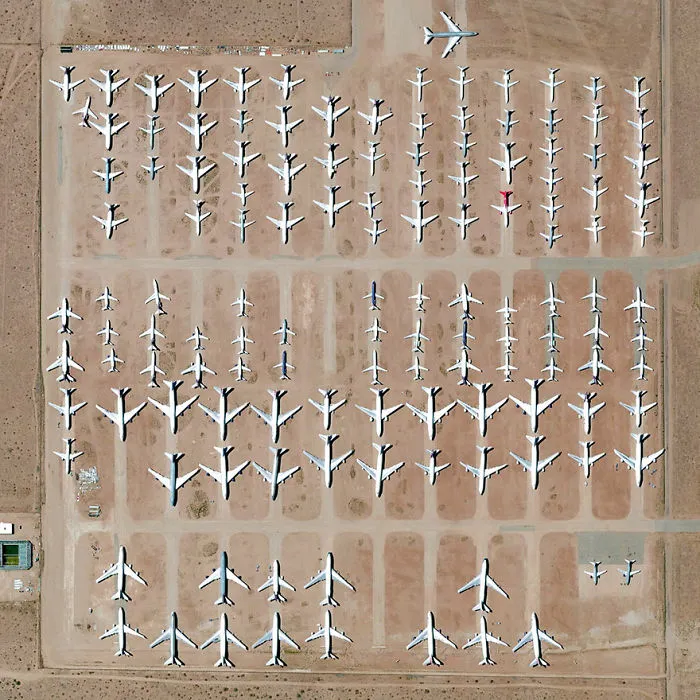
34°35′51″N 117°22′59″W. Here’s one of my favorite images from the Where We Waste chapter of “Overview”. The Southern California Logistics Airport in Victorville, California contains an aircraft boneyard with more than 150 retired planes. Because the demand for jumbo jets has dropped significantly in the last two decades in favor of smaller, more affordable twin‑engine planes, many large aircrafts such as Boeing 747s have been retired. The dry conditions in Victorville – located on the edge of the Mojave Desert – limits the corrosion of metal, meaning planes can be stored here for years while they are stripped for spare parts.
17points
#30 Bastille Day, Paris, France

48.8738°N 2.2950°E. Bastille Day or La Fête National as its known in France. The holiday commemorates the start of the French Revolution which began in 1789 with the Storming of the Bastille, a fortress and prison. In modern times, the day's most celebrated event is a military parade through Paris that begins at the Arc de Triomphe - seen in this Overview - and ends at Place de la Concorde. Joyeux Quatorze Juliet!
17points
#31 Statue Of Liberty, New York City, USA

40°41′21″N 74°2′40″W. The incredible shot shows the Statue of Liberty in New York City. The colossal copper structure depicts a robed female figure — Libertas, the Roman goddess of liberty — who bears a torch and a tablet upon which is inscribed the date of the American Declaration of Independence — July 4, 1776. The statue is an American icon of freedom and a welcoming sight to immigrants arriving from abroad.
17points
#32 Glacial Melt, Skafta River, Iceland
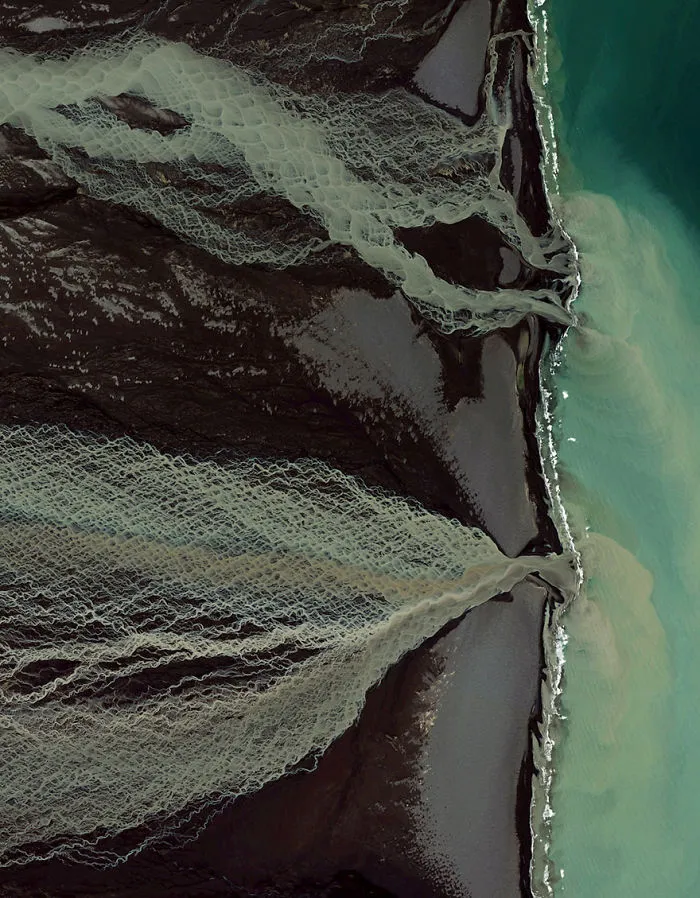
63.7751116, -18.09628. Glacial melting and flooding occurs every year by the Skafta River in Iceland. As the water travels down towards the North Atlantic Ocean, incredible patterns are created on the hillsides. Rising lava, steam vents, or newly opened hot springs can all cause this rapid ice melt, leading to a sizable release of water that picks up sediment as it flows down from the glaciers.
16points
#33 Lebrija 1 Solar Power Plant, Lebrija, Spain

37.007977710°, -6.049280818°. The Lebrija 1 Solar Power Plant in Lebrija, Spain is comprised of approximately 170,000 individual mirrors installed on 6,048 parabolic troughs. If placed next to one another, the troughs would extend for 60 kilometers.
16points
#34 Löyly, Helsinki, Finland

60.152008, 24.921262. Löyly is a public sauna located on the edge of the Baltic Sea in Helsinki, Finland. The building, constructed with repurposed wood, features a shell-like design that has been described as a “tunturi” - the Finnish word for something in between a hill and a mountain. In total, Finland contains approximately 3.3 million saunas or roughly one per household. This incredible shot was shared with us by @joelmiikka
15points
#35 Istanbul, Turkey

Istanbul is the largest metropolitan area in Turkey, with a population of more than 14 million people.
15points

#37 Lombard Street, San Francisco, California, USA

37.802317, -122.419740. Lombard Street runs from east to west in San Francisco, California, USA. With eight hairpin turns dispersed over a one-block section in the Russian Hill neighborhood, Lombard is often referred to as "the most crooked street in the world.”
15points
#38 Great Wall Of China, Northern China

40.67693°N 117.23193°E
14points
#39 Sydney Opera House, Australia

33°51′31.2″S 151°12′50.5″E. The Sydney Opera House hosts more than 1,500 shows each year in its various performance halls, drawing a total attendance of approximately 1.2 million people. While the buildings famous “shell” design appears uniformly white from a distance, it actually features a subtle chevron pattern composed of tiles in two colors: glossy white and matte cream.
13points
#40 Coastline, El Hur, Somalia
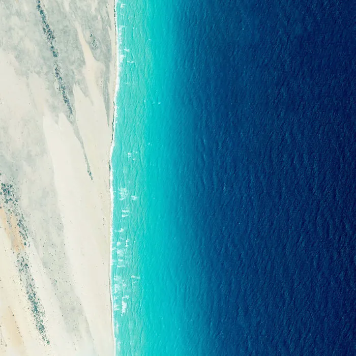
5°00′N 48°16′E. Waves roll into the shores of Somalia, by the village of El Hur. Located on the Horn of Africa, Somalia has the longest coastline on the mainland continent, stretching for more than 3,000 kilometers (1880 miles).
13points