



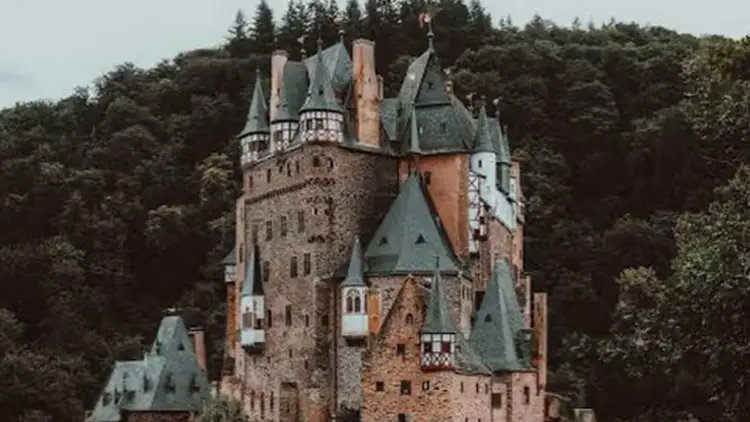


If you're anything like me, then finding old buildings is possibly one of the best vacation activities ever. I love checking out the history and stories behind a place, and even cobblestones have a story to tell.
But, of course, vacations get pricey, and if you visit historical sites, things can get even tougher on your wallet. Nobody in a normal tax bracket can really afford that. So, we've compiled a list of historical sites with fascinating histories that you can experience from the comfort of your home, or just to add to your list for your next holiday.
#21
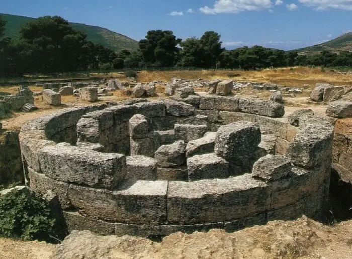
The Tholos at Epidaurus, 🔘 also known as the Thymele, was a magnificent 4th-century BCE circular building designed by architect Polykleitos the Younger within the Sanctuary of Asklepios. Renowned for its intricate design and, in antiquity, as the most perfect round building, it featured 26 outer Doric columns and 14 inner Corinthian columns, with a mysterious, labyrinthine underground basement.
Archaeologists believe that the tholos was the most importance building at the Sanctuary of Asclepius. It use is uncertain. It may have also been used as an abaton or a place for the priests of the sanctuary to eat.
Nevertheless, this building is interest due to the subterranean maze which it housed. One could only speculate as to the purpose of this maze. It may have been a place where offerings were made to the gods of the underworld. Perhaps patients were left to wander the maze, potentially finding at its centre a pit of snakes. Some suggest the maze may have acted a form of shock treatment for particular psychiatric cases.
On the exterior stood a Doric peristyle consisting of 26 Doric columns, which enclosed a Doric *septum*. A second circular colonnade, composed of 14 marble columns with Corinthian capitals, adorned the interior of the cella. The floor within the Corinthian colonnade consisted of white and black rhombic ❗️slabs arranged in a unique geometric pattern. According to Pausanias, paintings by the artist Pausias were located inside the cella. Both the Doric colonnade and the Corinthian peristyle supported a roof featuring marble panels decorated with floral motifs. The building was crowned by a conical wooden roof, covered by an intricate system of marble tiles, while an elaborate floral finial surmounted the very top of the roof.
Archaeologists believe that the tholos was the most importance building at the Sanctuary of Asclepius. It use is uncertain. It may have also been used as an abaton or a place for the priests of the sanctuary to eat.
Nevertheless, this building is interest due to the subterranean maze which it housed. One could only speculate as to the purpose of this maze. It may have been a place where offerings were made to the gods of the underworld. Perhaps patients were left to wander the maze, potentially finding at its centre a pit of snakes. Some suggest the maze may have acted a form of shock treatment for particular psychiatric cases.
On the exterior stood a Doric peristyle consisting of 26 Doric columns, which enclosed a Doric *septum*. A second circular colonnade, composed of 14 marble columns with Corinthian capitals, adorned the interior of the cella. The floor within the Corinthian colonnade consisted of white and black rhombic ❗️slabs arranged in a unique geometric pattern. According to Pausanias, paintings by the artist Pausias were located inside the cella. Both the Doric colonnade and the Corinthian peristyle supported a roof featuring marble panels decorated with floral motifs. The building was crowned by a conical wooden roof, covered by an intricate system of marble tiles, while an elaborate floral finial surmounted the very top of the roof.
Report
10points
#22
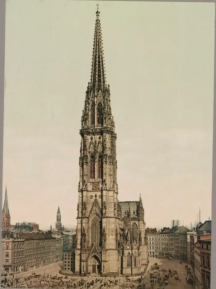
The Church of St. Nicholas ⛪️ is a neo Gothic Revival cathedral that was formerly one of the five Lutheran Hauptkirchen (main churches) in the city of Hamburg, Germany.
With the founding of the Nikolai settlement and a harbor on the Alster in the 12th century, a chapel dedicated to Saint Nicholas, patron saint of sailors, was erected. This wood building was the second church in Hamburg, after St. Mary’s Cathedral. In 1335, some years before the onslaught of the Black D***h, construction on a new brick building began. The structure was to be a three-naved hall church in the typical North German Brick Gothic style. This building stood until the middle of the 19th century, undergoing changes, expansions, and withstanding several partial destructions. The tower, which was erected in 1517, burned down in 1589. The tower built to replace it collapsed in 1644.
The old Church of St. Nicholas was the first large public building to burn in the Great Fire of Hamburg of May 1842. 🔥The destruction of the Church of St. Nicholas is described by chroniclers as a particularly moving event for the citizens.
Shortly after the fire, the church was rebuilt again. In 1843, a so-called “shilling collection” was started, and in 1844 there was an architectural competition, won by the architect Gottfried Semper with the draft of a Romanesque domed structure. Shortly before this time, the completion of the medieval Cologne cathedral in 1842 had led to a Gothic Revival in Germany. Hamburg’s own medieval cathedral had been demolished in 1805.
The clearly visible tower of the Church of St. Nicholas served as a goal and orientation marker for pilots of the Allied Air Forces during the extensive air raids on Hamburg. On 28 July 1943, the church was heavily damaged by aerial bombs. The roof collapsed and the interior of the nave suffered heavy damage. The walls began to show cracks, yet neither they nor the tower collapsed.
The current condition of the Church of St. Nicholas is the result of the bombing of Hamburg in World War II, the removal of its ruined walls and rubble in 1951 and restoration work to the tower in the 1990s and 2012.
With the founding of the Nikolai settlement and a harbor on the Alster in the 12th century, a chapel dedicated to Saint Nicholas, patron saint of sailors, was erected. This wood building was the second church in Hamburg, after St. Mary’s Cathedral. In 1335, some years before the onslaught of the Black D***h, construction on a new brick building began. The structure was to be a three-naved hall church in the typical North German Brick Gothic style. This building stood until the middle of the 19th century, undergoing changes, expansions, and withstanding several partial destructions. The tower, which was erected in 1517, burned down in 1589. The tower built to replace it collapsed in 1644.
The old Church of St. Nicholas was the first large public building to burn in the Great Fire of Hamburg of May 1842. 🔥The destruction of the Church of St. Nicholas is described by chroniclers as a particularly moving event for the citizens.
Shortly after the fire, the church was rebuilt again. In 1843, a so-called “shilling collection” was started, and in 1844 there was an architectural competition, won by the architect Gottfried Semper with the draft of a Romanesque domed structure. Shortly before this time, the completion of the medieval Cologne cathedral in 1842 had led to a Gothic Revival in Germany. Hamburg’s own medieval cathedral had been demolished in 1805.
The clearly visible tower of the Church of St. Nicholas served as a goal and orientation marker for pilots of the Allied Air Forces during the extensive air raids on Hamburg. On 28 July 1943, the church was heavily damaged by aerial bombs. The roof collapsed and the interior of the nave suffered heavy damage. The walls began to show cracks, yet neither they nor the tower collapsed.
The current condition of the Church of St. Nicholas is the result of the bombing of Hamburg in World War II, the removal of its ruined walls and rubble in 1951 and restoration work to the tower in the 1990s and 2012.
Report
10points
#23
The Saint-Uzec menhir 📜 (also Saint-Duzec or Saint Uzee) is located approximately 2.5 kilometers northeast of Trébeurden in the Côtes-d’Armor department of Brittany, France. It stands about 600 meters north of the chapel of the same name, on the old road from Penvern to Pleumeur-Bodou.
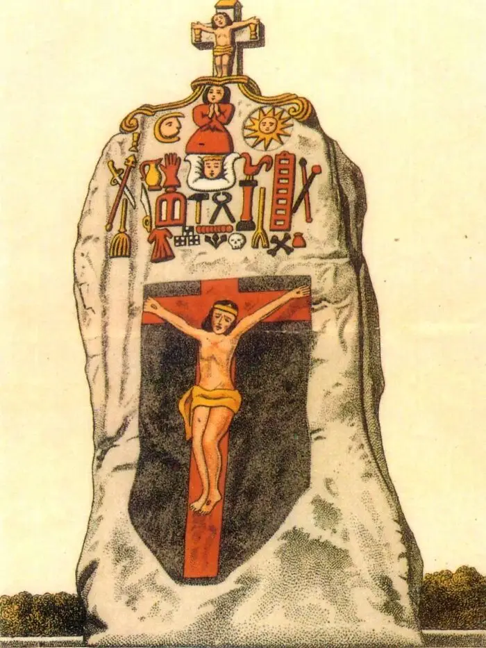
The menhir is approximately eight meters high and three meters wide, making it the largest menhir in France adorned with Christian symbols. Its sculpting by the Jesuit priest and Breton orthographer Julien Maunoir (1606–1683), also known as the „Apostle of Brittany,“ took place in 1674 as a declaration of war against the supposedly resurgent paganism. The redesigned menhir could be incorporated as a station in processions. A crucifix stands at its top. In addition to the moon and sun, scenes of adoration and the instruments of the Passion, or Arma Christi (hammer, nails, whip, and others), are carved into the south side ⚒️
Well into the 20th century, the Catholic menhir was adorned with colorful Baroque paintings on the altar side. However, the smooth yellow granite could not halt the rapid weathering of the paintings, caused by environmental influences and increasing changes in the climate’s pH value, so that nothing remains of them today. Because of the very naive depiction of the hanging Jesus, the restoration or re-establishment of the menhir’s paintings was not undertaken.
The granite menhir was erected around 2500 BC. On the north side, a 25 cm deep groove in the stone indicates that it lay in place for a period of time. The back side shows vertical grooves that only form while the stone is standing 🪨
Approximately 900 m to the north lies the Keryvon covered wayside shrine. Both are part of a network of cultic stone rows that were, or still are, scattered throughout Brittany (e.g., in Carnac).
The menhir is approximately eight meters high and three meters wide, making it the largest menhir in France adorned with Christian symbols. Its sculpting by the Jesuit priest and Breton orthographer Julien Maunoir (1606–1683), also known as the „Apostle of Brittany,“ took place in 1674 as a declaration of war against the supposedly resurgent paganism. The redesigned menhir could be incorporated as a station in processions. A crucifix stands at its top. In addition to the moon and sun, scenes of adoration and the instruments of the Passion, or Arma Christi (hammer, nails, whip, and others), are carved into the south side ⚒️
Well into the 20th century, the Catholic menhir was adorned with colorful Baroque paintings on the altar side. However, the smooth yellow granite could not halt the rapid weathering of the paintings, caused by environmental influences and increasing changes in the climate’s pH value, so that nothing remains of them today. Because of the very naive depiction of the hanging Jesus, the restoration or re-establishment of the menhir’s paintings was not undertaken.
The granite menhir was erected around 2500 BC. On the north side, a 25 cm deep groove in the stone indicates that it lay in place for a period of time. The back side shows vertical grooves that only form while the stone is standing 🪨
Approximately 900 m to the north lies the Keryvon covered wayside shrine. Both are part of a network of cultic stone rows that were, or still are, scattered throughout Brittany (e.g., in Carnac).
Report
10points
#24
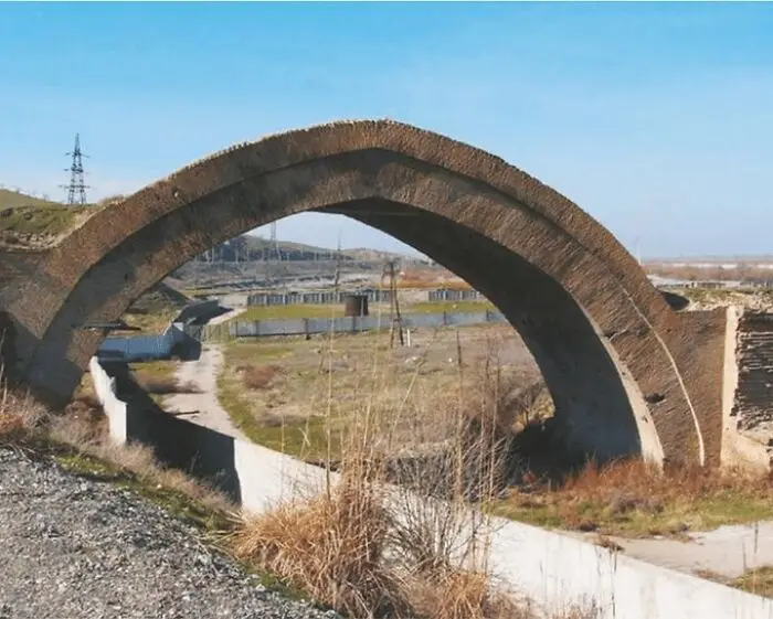
Zarafshan Bridge📜 is an architectural monument located 7–8 km northeast of Samarkand on the left bank of the Zarafshan River (Samarkand Region, Uzbekistan). The bridge was built in the year 1502 by the order of Muhammad Shaybani. It served as a water divider on the Zarafshan River, giving rise to two branches—Akdarya and Karadarya.
In historical sources, the bridge is mentioned under various names such as „Timur’s Arch,“ „Puli Shadman Malik,“ and „Abdullah Khan’s Bridge“. In the mid-15th century, the bridge across the Zarafshan River was destroyed by a flood. The construction history of this monument is detailed in the work „Sheybani-name“ by Kamal ad-Din Binai, a historian and poet who lived in the second half of the 15th to the early 16th century. ❗️The bridge was 200 meters long and consisted of seven arches. It is also unknown when and under what circumstances the bridge began to deteriorate.The bridge is a complex structure. Samarkand craftsmen prepared a special mortar for it, similar to modern cement. Gypsum, lime, and plant ash were used in different places, depending on the degree of contact with water, to make the mortar.❗️
Most likely, two arches were destroyed during the earthquakes of 1886 and 1898. In 1962, as a result of archaeological excavations conducted by Abdulakhad Muhammadjanov, the remains of the collapsed second and third arches of the bridge were discovered and studied. Railings, one meter in height and width, made of fired brick, were constructed on both sides of the bridge. This type of construction indicates that the engineers of the 16th century, who designed this structure, took into account safety measures for those crossing the river. 🧱
In historical sources, the bridge is mentioned under various names such as „Timur’s Arch,“ „Puli Shadman Malik,“ and „Abdullah Khan’s Bridge“. In the mid-15th century, the bridge across the Zarafshan River was destroyed by a flood. The construction history of this monument is detailed in the work „Sheybani-name“ by Kamal ad-Din Binai, a historian and poet who lived in the second half of the 15th to the early 16th century. ❗️The bridge was 200 meters long and consisted of seven arches. It is also unknown when and under what circumstances the bridge began to deteriorate.The bridge is a complex structure. Samarkand craftsmen prepared a special mortar for it, similar to modern cement. Gypsum, lime, and plant ash were used in different places, depending on the degree of contact with water, to make the mortar.❗️
Most likely, two arches were destroyed during the earthquakes of 1886 and 1898. In 1962, as a result of archaeological excavations conducted by Abdulakhad Muhammadjanov, the remains of the collapsed second and third arches of the bridge were discovered and studied. Railings, one meter in height and width, made of fired brick, were constructed on both sides of the bridge. This type of construction indicates that the engineers of the 16th century, who designed this structure, took into account safety measures for those crossing the river. 🧱
Report
10points
#25
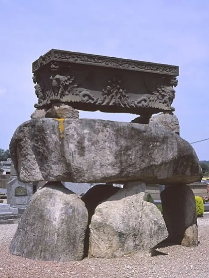
Dolmen de Confolens – France (Dolmen de Périssac) 🪨 This Neolithic dolmen is located in the cemetery of the town on Confolens. It was moved here in the 19th century to house the tomb of the wife of the sub-prefect Cecile-Jeanne-Marie Crevelier.
The 10 tonne capstone was transported by a carter from Périssac to Confolens over a distance of several kilometres using 18 horses who struggled for three days to move the block. In 1899 the bulletin of the Archaeological Society reported that the capstone was already broken into two parts, but many believe that it was actually cut for the occasion. This is based on a photo dated from 1883 which supposedly shows the dolmen in it’s original state two years previously.. and the other piece of the capstone lies on the ground a few meters from the pillars with clear chisel marks.
According to Archaeologist Glyn Daniel, this “simple dolmen was bought for 100 francs in 1892 and moved nearly 5 km from Périssac to the town churchyard – as a support for the sarcophagus of a lady much addicted to dolmens”.
It’s said that the sacrilegious entrepreneur who destroyed the megalith was condemned, along with his horses, to wander forever around the ruins where their gallop can be heard as midnight approaches..The children of the country, with sticks, hit the remaining part of the dolmen table and press their ears to it, to hear the gallop of the damned horses.
The 10 tonne capstone was transported by a carter from Périssac to Confolens over a distance of several kilometres using 18 horses who struggled for three days to move the block. In 1899 the bulletin of the Archaeological Society reported that the capstone was already broken into two parts, but many believe that it was actually cut for the occasion. This is based on a photo dated from 1883 which supposedly shows the dolmen in it’s original state two years previously.. and the other piece of the capstone lies on the ground a few meters from the pillars with clear chisel marks.
According to Archaeologist Glyn Daniel, this “simple dolmen was bought for 100 francs in 1892 and moved nearly 5 km from Périssac to the town churchyard – as a support for the sarcophagus of a lady much addicted to dolmens”.
It’s said that the sacrilegious entrepreneur who destroyed the megalith was condemned, along with his horses, to wander forever around the ruins where their gallop can be heard as midnight approaches..The children of the country, with sticks, hit the remaining part of the dolmen table and press their ears to it, to hear the gallop of the damned horses.
Report
10points
#26
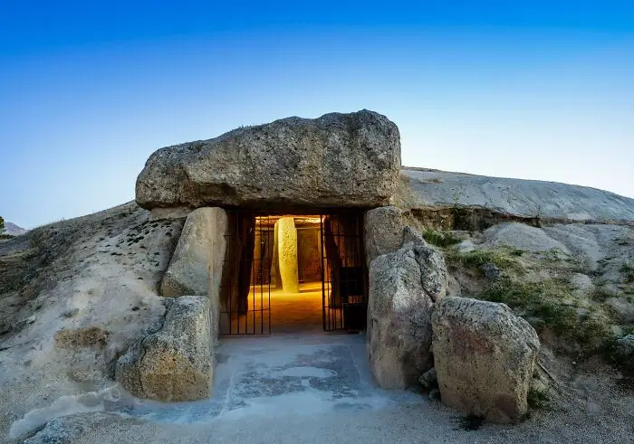
The Dolmen of Menga 🪨 is a megalithic burial mound called a tumulus, a long barrow form of dolmen, dating from the Neolithic period around 3750–3650 BCE. It is near Antequera, Málaga, Spain.
It is one of the largest known ancient megalithic structures in Europe.It is 27.5 metres long, 6 metres wide and 3.5 metres high, and was built with thirty-two megaliths, the largest weighing about 180 tonnes 📜
After completion of the chamber (which probably served as a grave for the ruling families) and the path leading into the center, the stone structure was covered with soil and built up into the hill that can be seen today. When the grave was opened and examined in the 19th century, archaeologists found the skeletons of several hundred people inside. The dolmen sits 70 metres from the Dolmen de Viera and about 4 kilometres from another subterranean structure known as Tholos de El Romeral.
The Abrigo (shelter) of Matacabras, located at the foot of the northwest face of the Peña de los Enamorados, is closely linked with the Dolmen of Menga whose central axis points directly to it. The tomb is orientated to the northeast, north of the sunrise on the summer solstice, and is the only known tomb so oriented in Europe in this cultural context.
📌At the back of this giant dolmen, in the centre of the floor, is a 30m deep well perfectly carved from the bedrock and with water at its bottom
It is one of the largest known ancient megalithic structures in Europe.It is 27.5 metres long, 6 metres wide and 3.5 metres high, and was built with thirty-two megaliths, the largest weighing about 180 tonnes 📜
After completion of the chamber (which probably served as a grave for the ruling families) and the path leading into the center, the stone structure was covered with soil and built up into the hill that can be seen today. When the grave was opened and examined in the 19th century, archaeologists found the skeletons of several hundred people inside. The dolmen sits 70 metres from the Dolmen de Viera and about 4 kilometres from another subterranean structure known as Tholos de El Romeral.
The Abrigo (shelter) of Matacabras, located at the foot of the northwest face of the Peña de los Enamorados, is closely linked with the Dolmen of Menga whose central axis points directly to it. The tomb is orientated to the northeast, north of the sunrise on the summer solstice, and is the only known tomb so oriented in Europe in this cultural context.
📌At the back of this giant dolmen, in the centre of the floor, is a 30m deep well perfectly carved from the bedrock and with water at its bottom
Report
10points
#27
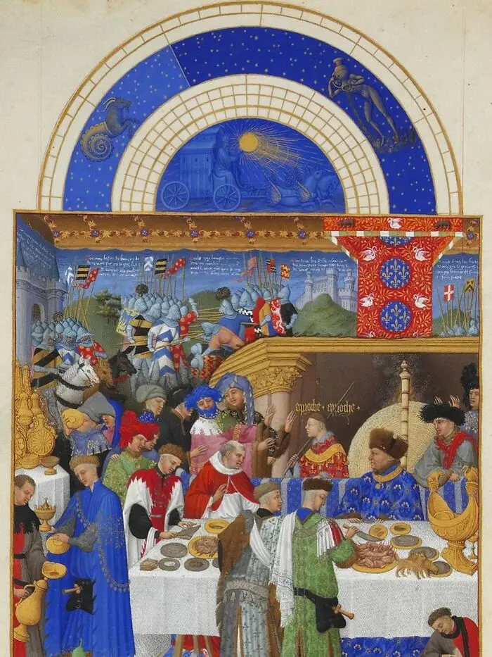
The Très Riches Heures du Duc de Berry (French pronunciation) ✨is an illuminated manuscript that was created between c. 1412 and 1416. It is a book of hours, which is a Christian devotional book and a collection of prayers said at canonical hours. The manuscript was created for John, Duke of Berry, the brother of King Charles V of France, by Limbourg brothers Paul, Johan and Herman.The book is now MS 65 in the Musée Condé, Chantilly, France ⭐️
To date, only 20 of the 31 notebooks remain quaternions; the rest have either had sheets added or sheets removed. The presence of unfinished sentences at the end of some notebooks, which have no continuation, also indicates that the manuscript has not been preserved in its entirety. The book of hours contains blank pages, both lined and unlined.
Each miniature is crowned with a semicircle (tympanum), which depicts a solar chariot driven by Phoebus, the zodiac signs corresponding to the given month, and its degrees. The calendar indicates the days of the month, their duration in hours and minutes, church holidays and the names of saints, and golden numbers, which were used to determine the place of the calendar year in the Metonic cycle.
🏰 Well, for us, of primary interest are his miniatures depicting castles. Moreover, they were obviously drawn with great precision, which is why restorers of those that have survived to this day used the drawings as models for reconstruction, although not always.
To date, only 20 of the 31 notebooks remain quaternions; the rest have either had sheets added or sheets removed. The presence of unfinished sentences at the end of some notebooks, which have no continuation, also indicates that the manuscript has not been preserved in its entirety. The book of hours contains blank pages, both lined and unlined.
Each miniature is crowned with a semicircle (tympanum), which depicts a solar chariot driven by Phoebus, the zodiac signs corresponding to the given month, and its degrees. The calendar indicates the days of the month, their duration in hours and minutes, church holidays and the names of saints, and golden numbers, which were used to determine the place of the calendar year in the Metonic cycle.
🏰 Well, for us, of primary interest are his miniatures depicting castles. Moreover, they were obviously drawn with great precision, which is why restorers of those that have survived to this day used the drawings as models for reconstruction, although not always.
Report
10points
#28
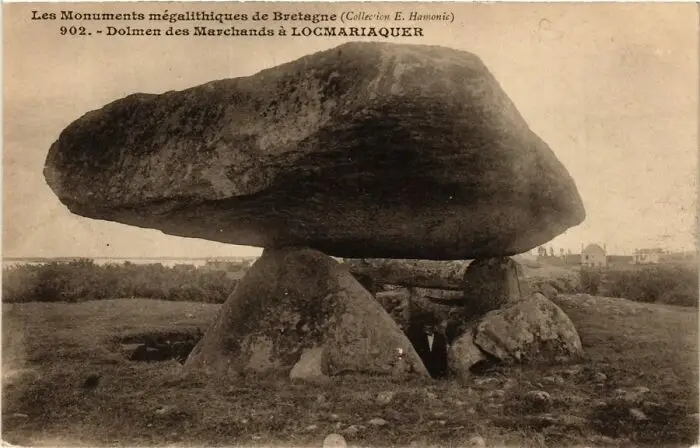
Table des Marchands 🪨 (German: Tisch der [Kaufmannsfamilie] Marchand, Breton: An Daol Varchant) is located in Locmariaquer in the Morbihan department of Brittany, France. The megalithic structure was declared a Monument history in 1889.
The dolmen and cairn were built between 3900 and 3800 BC. It is a tomb with a corridor ending in a burial chamber. The first excavations took place as early as 1811, but all the finds made then were later lost. ❗️At that time, the monument consisted of a slab resting on three supporting pillars. The monument was restored in 1883, and it was studied in 1937 by the renowned French megalithic researcher Zachary Le Rouzic.
Apparently used for many centuries, this monument consists of two engraved slabs. The slab, representing the floor of the chamber, was originally located outdoors and was a separate monument. The slab is decorated on both sides; the design on one side depicts a deity with lush hair.
The slab is carved with decorations in the form of a cross, an axe with a handle, and, on the underside, a bull. This slab is part of a block, another part of which is located at the Gavrini burial mound, 5 km away, and another at the Er-Grah burial mound; the ornamental motifs in these structures are completely identical.
❗️The present-day structure is a largely reconstructed dolmen within a stone mound. Excavations have shown that the building was originally enclosed by a two-tiered cairn made of small, broken stones, which—to protect against rainwater intrusion—may have been covered with sand, earth, and grass. However, the cairn or tumulus was dismantled centuries ago, leaving the structure for a long time as a monumental, table-shaped dolmen (hence the name)❗️
The stone material used in the construction was mainly locally sourced granite;
The dolmen and cairn were built between 3900 and 3800 BC. It is a tomb with a corridor ending in a burial chamber. The first excavations took place as early as 1811, but all the finds made then were later lost. ❗️At that time, the monument consisted of a slab resting on three supporting pillars. The monument was restored in 1883, and it was studied in 1937 by the renowned French megalithic researcher Zachary Le Rouzic.
Apparently used for many centuries, this monument consists of two engraved slabs. The slab, representing the floor of the chamber, was originally located outdoors and was a separate monument. The slab is decorated on both sides; the design on one side depicts a deity with lush hair.
The slab is carved with decorations in the form of a cross, an axe with a handle, and, on the underside, a bull. This slab is part of a block, another part of which is located at the Gavrini burial mound, 5 km away, and another at the Er-Grah burial mound; the ornamental motifs in these structures are completely identical.
❗️The present-day structure is a largely reconstructed dolmen within a stone mound. Excavations have shown that the building was originally enclosed by a two-tiered cairn made of small, broken stones, which—to protect against rainwater intrusion—may have been covered with sand, earth, and grass. However, the cairn or tumulus was dismantled centuries ago, leaving the structure for a long time as a monumental, table-shaped dolmen (hence the name)❗️
The stone material used in the construction was mainly locally sourced granite;
Report
9points
#29
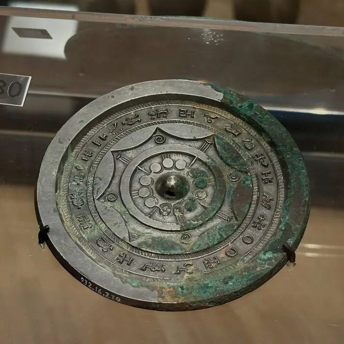
Bronze mirrors 🪞were produced in China from Neolithic times, until Western
glass mirrors were brought to China. In China, these mirrors are called to’ou kuang ching, literally «transparent mirrors.» You can also find the names «transparent» or «magic» mirrors ✨Bronze mirrors were usually circular, with one side polished bright, to give a reflection, and the reverse side normally decorated in cast relief in early examples, later on sometimes inlaid in precious metal. They generally had a knob or loop in the center of the back so that they could be easily held in the hand, and sometimes attached to clothing.
Some of the earliest examples of Chinese bronze mirrors belonged to the late Neolithic Qijia culture from around 2000 BCE (some use of bronze is found before the Bronze Age).
❗️For over a thousand years, a rare type of Chinese artifact has puzzled researchers. It is a polished bronze mirror with a pattern cast on the back. The polished surface is unremarkable and can be used as an ordinary mirror. But when a bright light falls on the mirror and the reflected light is projected onto the surface, the pattern printed on the back side mysteriously appears in the projected reflection, as if the hard bronze mirror had become transparent.
The art of making magic mirrors dates back to the Han Dynasty (206 BC – 24 AD). It was passed down until at least the 8th and 9th centuries. In the 800s, a book called “The Record of Ancient Mirrors” was published that apparently contained all the secrets. It has not survived to this day 📜
glass mirrors were brought to China. In China, these mirrors are called to’ou kuang ching, literally «transparent mirrors.» You can also find the names «transparent» or «magic» mirrors ✨Bronze mirrors were usually circular, with one side polished bright, to give a reflection, and the reverse side normally decorated in cast relief in early examples, later on sometimes inlaid in precious metal. They generally had a knob or loop in the center of the back so that they could be easily held in the hand, and sometimes attached to clothing.
Some of the earliest examples of Chinese bronze mirrors belonged to the late Neolithic Qijia culture from around 2000 BCE (some use of bronze is found before the Bronze Age).
❗️For over a thousand years, a rare type of Chinese artifact has puzzled researchers. It is a polished bronze mirror with a pattern cast on the back. The polished surface is unremarkable and can be used as an ordinary mirror. But when a bright light falls on the mirror and the reflected light is projected onto the surface, the pattern printed on the back side mysteriously appears in the projected reflection, as if the hard bronze mirror had become transparent.
The art of making magic mirrors dates back to the Han Dynasty (206 BC – 24 AD). It was passed down until at least the 8th and 9th centuries. In the 800s, a book called “The Record of Ancient Mirrors” was published that apparently contained all the secrets. It has not survived to this day 📜
Report
9points
#30
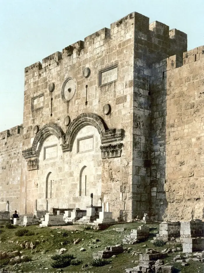
The Golden Gate ✨ is the only eastern gate of the Temple Mount, and one of only two Gates of the Old City of Jerusalem that used to offer access into the city from the East side. The gate has been sealed since 1541, the most recent of several sealings. Its interior can be accessed from the Temple Mount. In Jewish tradition, the Messiah will enter Jerusalem through this gate, coming from the Mount of Olives.Christians and Muslims generally believe that this was the gate through which Jesus entered Jerusalem.
The Golden Gate is a rectangular stonework structure with two decorated facades. Unlike other gates in al-Aqsa enclave, the eastern façade was not built level with the wall of the enclave, but projects two meters out from the wall.The Golden Gate has two passages. The two bays are reflected in its plan and main elevations; two doorways are followed by a double passage covered by three pairs of domes. On the ground floor level a vaulted hall is divided by four columns into two aisles, which lead to the Door of Mercy, Bab al-Rahma, and the Door of Repentance, Bab al-Taubah; an upper floor room has the two roof domes as its ceiling.
The 1st-century historian, Josephus, mentions an «eastern gate» in his Antiquities of the Jews, and makes note of the fact that this gate was considered within the far northeastern extremity of the inner sacred court.The Mishnah mentions a former causeway which led out of the Temple Mount eastward over the Kidron valley, extending as far as the Mount of Olives.Rabbi Eliezer, dissenting, says that it was not a causeway, but rather marble pillars over which cedar boards had been laid, used by the High Priest and his entourage.This gate, known as the Shushan Gate, was not used by the masses to enter the Temple Mount, but reserved only for the High Priest and all those that aided him when taking out the Red Heifer or the scapegoat on Yom Kippur.
The Golden Gate is a rectangular stonework structure with two decorated facades. Unlike other gates in al-Aqsa enclave, the eastern façade was not built level with the wall of the enclave, but projects two meters out from the wall.The Golden Gate has two passages. The two bays are reflected in its plan and main elevations; two doorways are followed by a double passage covered by three pairs of domes. On the ground floor level a vaulted hall is divided by four columns into two aisles, which lead to the Door of Mercy, Bab al-Rahma, and the Door of Repentance, Bab al-Taubah; an upper floor room has the two roof domes as its ceiling.
The 1st-century historian, Josephus, mentions an «eastern gate» in his Antiquities of the Jews, and makes note of the fact that this gate was considered within the far northeastern extremity of the inner sacred court.The Mishnah mentions a former causeway which led out of the Temple Mount eastward over the Kidron valley, extending as far as the Mount of Olives.Rabbi Eliezer, dissenting, says that it was not a causeway, but rather marble pillars over which cedar boards had been laid, used by the High Priest and his entourage.This gate, known as the Shushan Gate, was not used by the masses to enter the Temple Mount, but reserved only for the High Priest and all those that aided him when taking out the Red Heifer or the scapegoat on Yom Kippur.
Report
8points
