
Bored Panda
41 Maps That Portray The Lesser Known Facts About America
HistoryJAN 30, 2026

41 Maps That Portray The Lesser Known Facts About America

0
0
For every Internet commenter who enters online arguments about the USA with facts they got from their b**t, there's a map that presents hard data bare and allows the viewers to make their own interpretations.
From light pollution and tree coverage to out-of-service railways and streets and highways, maps may not immediately look as exciting as a viral cat video -- which might explain why we often overlook them when -- but that doesn't mean that are boring. To prove that, we put together a selection of maps that explain the United States better then most textbooks and if broadening your worldview isn't thrilling, I don't know what is.
Click here & follow us for more lists, facts, and stories.
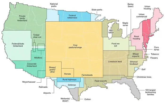
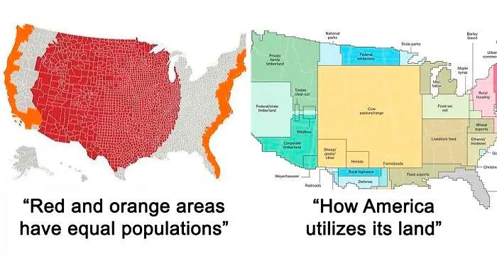
#21 How America Utilizes Its Land

Map of America highlighting lesser known facts about land use including timberland, farming, housing, and natural resources distribution.
0points

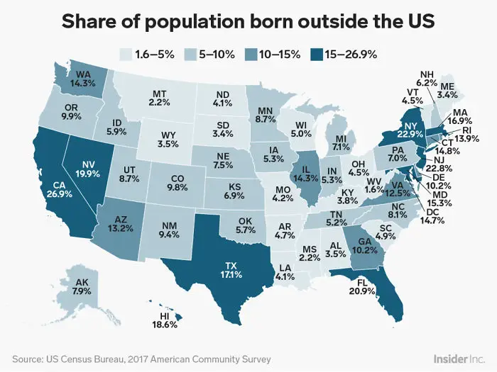
#22 Percentage Of People Born Outside The U.S. In Each State

Map showing the share of population born outside the US by state with varying percentages across America.
0points

#23 Regions Of The U.S. That Don't Officially Celebrate Christopher Columbus Day
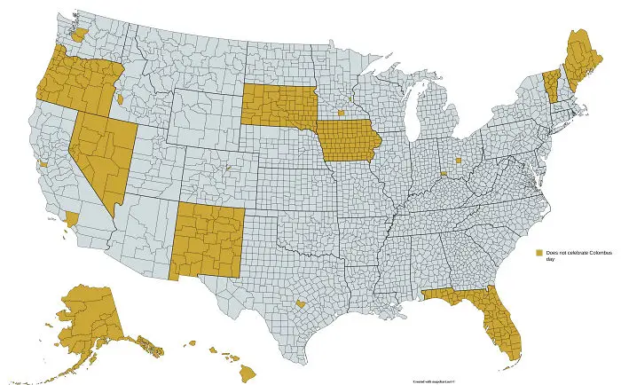
Map of America highlighting counties and states that do not celebrate Columbus Day, showing lesser known facts about America.
0points

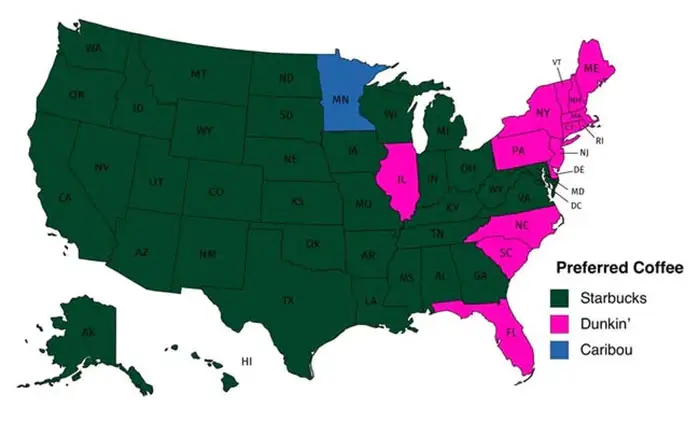
#24 Popular Coffee Shop Chains By Number Of Locations

Map showing preferred coffee brands across America, highlighting lesser known facts about regional coffee preferences.
Report
0points

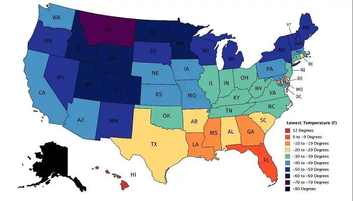
#25 Map Of Lowest Recorded Temperature In Each Us State (Fahrenheit)

Map of the United States showing temperature variations with color coding, highlighting lesser known facts about America.
0points

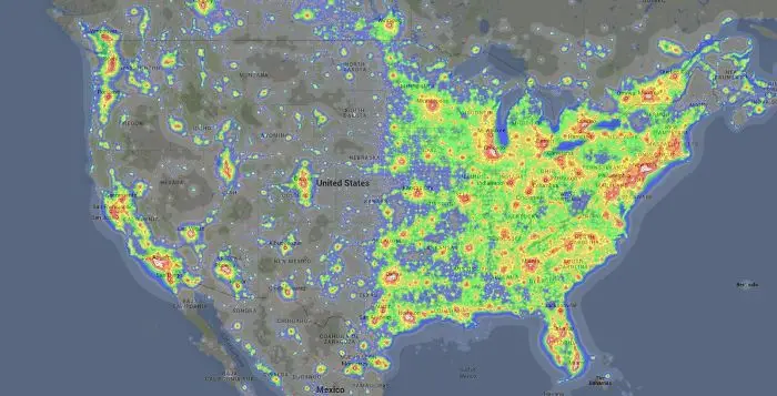
#26 Light Pollution In The United States

Heatmap showing population density and lesser known facts about America across the United States.
0points

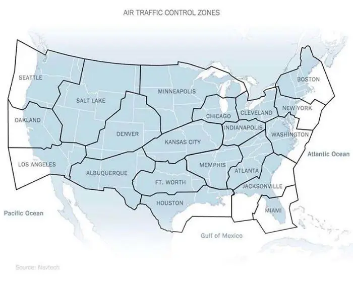
#27 Air Traffic Control Zones In The USA

Map of US air traffic control zones highlighting lesser known facts about America’s airspace regions.
0points

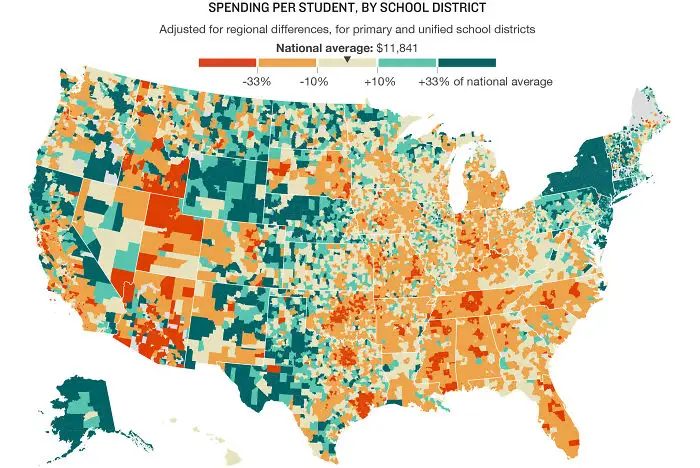
#28 U.S. Education Spending Map

Map of America showing per student spending by school district with adjusted regional differences and national average comparisons.
0points

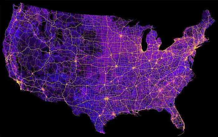
#29 Map Of The United States' 8 Million Miles Of Roads, Streets And Highways

Map of America with highlighted roads and city connections, illustrating lesser known facts about America’s geography and infrastructure.
0points

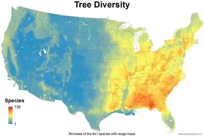
#30 USA Tree Diversity

Map of tree diversity across America showing the richness and range of tree species in different regions.
0points

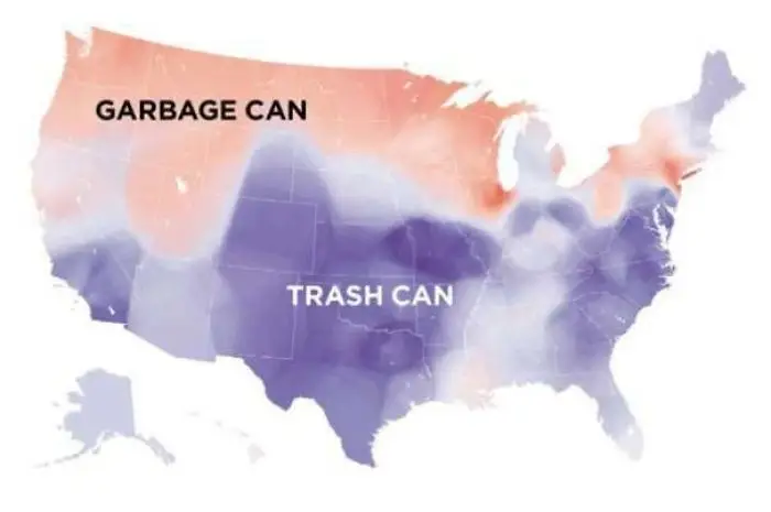
#31 Garbage Can vs. Trash Can In The United States

Map of America showing regional differences in terms used for garbage cans and trash cans across various states.
0points

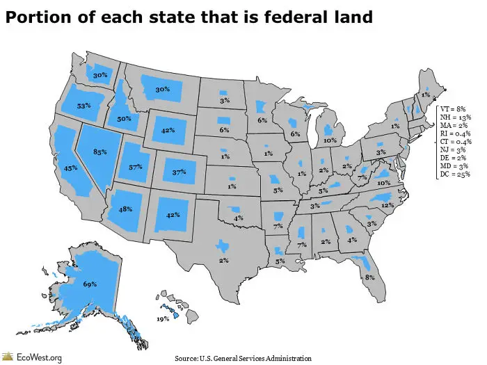
#32 Portion Of Each State That Is Federal Land

Map showing the portion of federal land in each US state highlighting lesser known America facts by percentage of land area.
0points

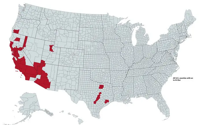
#33 All U.S. Counties With In-N-Out Burger As Of May 2020

Map of America highlighting counties with In-N-Out locations, illustrating lesser known facts about America.
0points

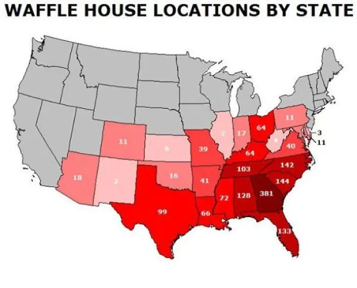
#34 A Tastier Map

Map showing Waffle House locations by state highlighting lesser known facts about America in a color-coded format.
0points

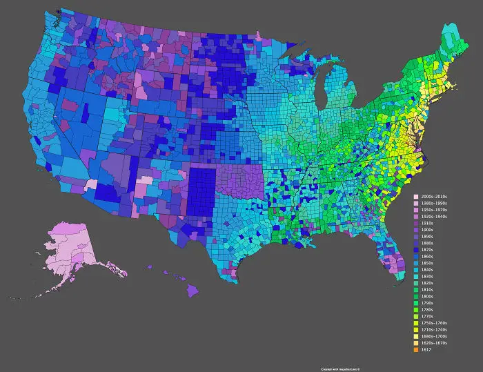
#35 Date Of Creation Of All 3,142 U.S. Counties

Color-coded map of America showing historical data by counties with varied shades representing different time periods.
0points

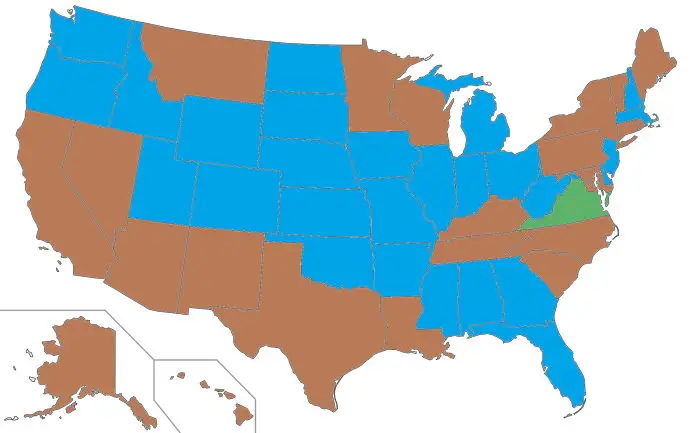
#36 US Governors By Eye Color

Map of America with states highlighted in blue, brown, and green, illustrating lesser known facts about America.
0points

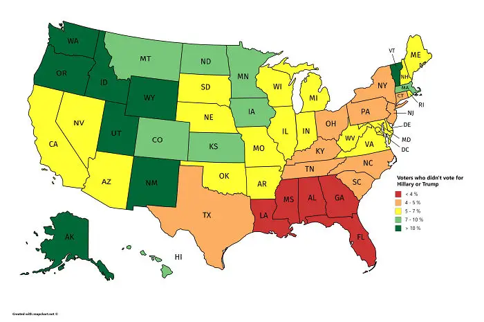
#37 Voters Who Didn't Vote For Hillary Or Trump

US map showing voters who didn’t vote for major candidates, highlighting lesser known facts about America voting patterns
0points

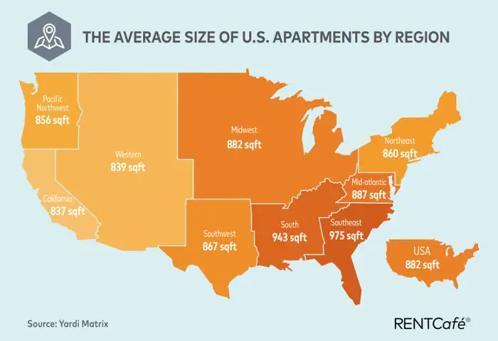
#38 Average Size Of US Apartments By Region

Map showing average apartment sizes in square feet across U.S. regions highlighting lesser known facts about America.
0points

#39 Results Of The 1984 United States Presidential Election By County. The Most Lopsided Election In History, The Only State Reagan Failed To Win Was His Opponent’s, Minnesota
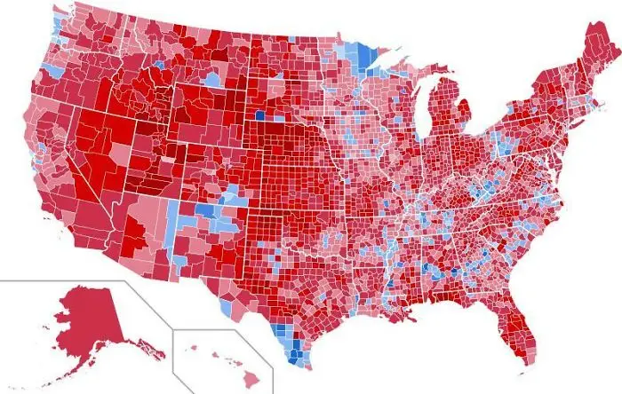
Color-coded map of America highlighting lesser known facts by county using red and blue shades across the United States.
0points

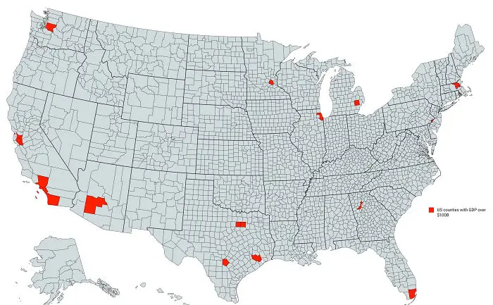
#40 US Counties With Gdp Over $100b

Map of America highlighting US counties with GDP over $100B in red, showcasing lesser known economic facts.
0points

Add New Image

Not your original work?

0
0
Asli Akalin
Asli AkalinBoredPanda Staff